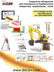
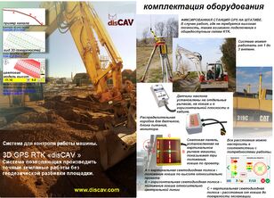
İtalya'da Üretilen Greyder Veya Buldozer Için 3D GPS DisCAV Sistemi


The height of the slope being built, the slope, the turn - the machine exactly repeats the model of the road embedded in the computer, with the Windows 10 operating system.
How it works: The grader arrives at the planned road section...
The height of the slope being built, the slope, the turn - the machine exactly repeats the model of the road embedded in the computer, with the Windows 10 operating system.
How it works: The grader arrives at the planned road section. The survey is carried out by the operator directly from the cockpit, point A (beginning) and point B (end) of the planned section is marked in the center along the road, the slope data on the edges taken from the project is kept, the on-board computer performs the necessary calculations and after a few minutes the operator can start work on site planning. 3D GPS. The project can be made in the cockpit or downloaded from "AutoCAD".
Высоту строящегося наклона, уклон, поворот - машина точно повторяет вложенную в компьютер, с операционной системой "Windows 10", модель дороги.
Как это работает Грейдер приезжает на запланированный участок дороги. Съемка производится оператором непосредственно из кабины, по центру вдоль дороги отмечается точка А (начало) и точку В (конец) запланированного участка, водятся данные наклонов по краям, взятые из проекта, бортовой компьютер производит необходимые вычисления и уже через несколько минут оператор может приступать к работе по планировке участка. 3D GPS. Проект можно сложить в кабине, или скачать его с "AutoCAD".
Висоту нахилу, що будується, ухил, поворот - машина точно повторює вкладену в комп'ютер, з операційною системою "Windows 10", модель дороги.
Як це працює: Грейдер приїжджає на заплановану ділянку дороги. Зйомка проводиться оператором безпосередньо з кабіни, по центру вздовж дороги відзначається точка А (початок) і точку В (кінець) запланованої ділянки, водяться дані нахилів по краях, взяті з проекту, бортовий комп'ютер проводить необхідні обчислення і вже через кілька хвилин оператор може приступати до роботу з планування ділянки. 3D GPS. Проект можна скласти в кабіні, або завантажити його з "AutoCAD ".
L'altezza del pendio in costruzione, la pendenza, la svolta: la macchina ripete esattamente il modello della strada incorporato nel computer, con il sistema operativo Windows 10.
Come funziona: la livellatrice arriva al tratto stradale previsto. Il rilievo viene effettuato dall'operatore direttamente dalla cabina di pilotaggio, viene segnato al centro lungo la strada il punto A (inizio) e il punto B (fine) del tratto previsto, vengono conservati i dati di pendenza sui bordi ricavati dal progetto, il computer di bordo esegue i calcoli necessari e dopo pochi minuti l'operatore può iniziare a lavorare sulla pianificazione del cantiere. GPS 3D. Il progetto può essere realizzato nel pozzetto o scaricato da "AutoCAD".
Düşük fiyattan ekipman satın almaya karar verirseniz gerçek satıcı ile iletişime geçtiğinizden emin olun. Ekipmanın sahibi hakkında bulabildiğiniz kadar çok bilgi edinmeye çalışın. Hile yapmanın bir yolu da kendinizi gerçek bir şirket olarak göstermektir. Şüpheye düşmeniz halinde, geribildirim formu üzerinden ek kontrol yapmamız için bizi bilgilendirin.
Bir satın alma yapmaya karar vermeden önce seçtiğiniz ekipmanın ortalama fiyatını anlamak için çeşitli satış tekliflerini dikkatli bir şekilde inceleyin. Beğendiğiniz teklifin fiyatı benzerlerinden çok daha düşükse biraz düşünün. Önemli bir fiyat farkı gizlenen kusurların veya satıcının dolandırıcılık yapma çabasının bir göstergesi olabilir.
Benzer ekipman için ortalama fiyattan çok farklı fiyattaki bir ürünü satın almayın.
Şüpheli güvencelere ve ön ödemeli ürünlere onay vermeyin. Şüpheye düşmeniz halinde, ayrıntıları netleştirmekten çekinmeyin, ilave fotoğraflar ve ekipmanın belgelerini isteyin, belgelerin orijinalliğini kontrol edin, soru sorun.
En yaygın dolandırıcılık biçimi. Hileci satıcılar bir ekipmanı satın alma hakkınızı “ayırtmak” için belirli bir miktar peşin ödeme talep edebilir. Böylelikle dolandırıcılar yüksek miktarda para toplayıp ortadan kaybolabilirler, bir daha iletişime geçemezsiniz.
- Ön ödemenin karta transferi
- İletişim sırasında satıcı şüphe uyandırıyorsa para transferi işlemini doğrulayan belgeler olmadan peşin ödeme yapmayın.
- “Emanetçi” hesabına transfer
- Bu tür bir istek sizi harekete geçirmelidir, büyük ihtimalle bir dolandırıcı ile iletişim kuruyorsunuz.
- Benzer isimdeki bir şirket hesabına transfer
- Dikkatli olun, dolandırıcılar, adda küçük değişiklikler yaparak kendilerini iyi bilinen şirketler gibi göstermeye çalışabilir. Şirket adı şüpheliyse para transferi yapmayın.
- Gerçek bir şirketin faturasına kendi bilgilerini yerleştirme
- Bir transfer gerçekleştirmeden önce, belirtilen detayların doğru olduğundan ve belirtilen şirketle ilişkili olduğundan emin olun.
Satıcı iletişim bilgileri


 Ukrayna